Corinium, original capital of the Dubunni tribe.
Dollar Street used to be called Le Fosse.
The Querns, medieval crundles- used as a rabbit warren by the Abbot.
Whiteway used to be called Wiggoldway.
Dyer street used to be called Chipping Street , where they held markets.
Park Lane once called Lawditch Lane.
Castle Street.Black Jack lane, Park Street and Silver Street may frame the original castle site.
|
|
|
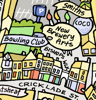
Map of Cirencester |
Gosditch Street used to be called Fosse Dyche street
Cecily Hill used to be called Inchstropp Street
Used to be three fairs, Easter Monday, 8th July and 8th Nov plus two mop fairs, the Monday before and the Monday after 10th October.
Woolmarket was on Fridays, Mondays were general, including silk, cheese,
salt, cattle, horse, iron ore, lead, brass, fish and bean flour..
St. Celia Chapel,(originally near bottom of Cecily Hill) is where
King Arthur was crowned, according to William of Worcester.
Alfred Hall built in 1721 by First Earl of Bathgate, where he thought
King Arthur had rested before battle at Ethandun.(Edinton in Wiltshire)
|
|
|
Map of Cirencester |

The 'Lai du Cor', story of the drinking Horn and King Arthur.
Alfreds Hall may be the earliest Gothic Garden building in Britain.
Thames and Severn canal was in Cirencester with Sheep Street being called
Wharf Street. They once hoped that it would join to Newport Canal,
so that they could get cheaper coal from Monmouth.
The basin was in Querns Road. Hammond Way was the canal feeder.
Cotswold ram breeders used to meet at The Bear.
Chapel on Sheep Street. Jerome K Jerome's author of Three men in a boats
father preached there.
John Beecham -Artist.
Abbey Grounds site of The Great Augustinian Abbey of St Mary.
Castle Street used to be called Battle Street.1643 the storming of Cirencester.
Weavers used to meet on St Catherine's Eve in a hall in St Thomas Hospital, to read their charter and elect new wardens.
Verulamiun Gate ( St Albans Gate), Ackerman Street went through this gate.
Gumstool bridge, after 'Gong' stool-Ducking stool.
David Hemerey- Gold medal athelete born in Cirencester.
Mrs Pankhurst visited Cirencester..Bingham Hall in 1911
King Canute held a great council in Cirencester.
Cirencester was a frontier garrison against the Mercians.
Twinned with Itzehoe in Germany.
Lloyds bank-built as a house for a wealthy wool merchant
Black Horse-oldest pub in Cirencester.
Crossing point of Fosse way, Ackerman Street and Ermin Street at junction of Tower Street and Lewis Lane.
Kings Arms became part of The Black Horse.
|
|
|
Map of Cirencester |

Cuda- an obscure British goddess sculpture,found in Cirencester, seated with three apples on her lap.
Cornhall built on the site of The Old Antelope Inn,
Kings Head- Medieval with more modern facade,
The Sun Inn once stood on the site of the Fleece.
St John the Baptist, Church has oldest 12 bell ring in the world.
Sparrows and Phoenix. Ancient story of the burning of Cirencester by attaching fire to the legs of sparrows who landed on thatched buildings . Cirencester grew like a phoenix out of the ashes,
.
|
|
|
Map of Cirencester |

![]()
Home of Neonplay, mobile games studio.
Barrington Ayre. Shirtmaker and Tailor Goldsmiths -Jewellers
HOBBS House Bakers
Decimal -Skateboarding shop
Loco Glass